Disclaimer: Please note that race information here represents what is planned for the Santa Clarita Trail Race. Locations, course variations, and changes may apply depending on conditions, availability, and improvements. We strive to make the best experience for the runners. Thank you for your understanding.
5K Course
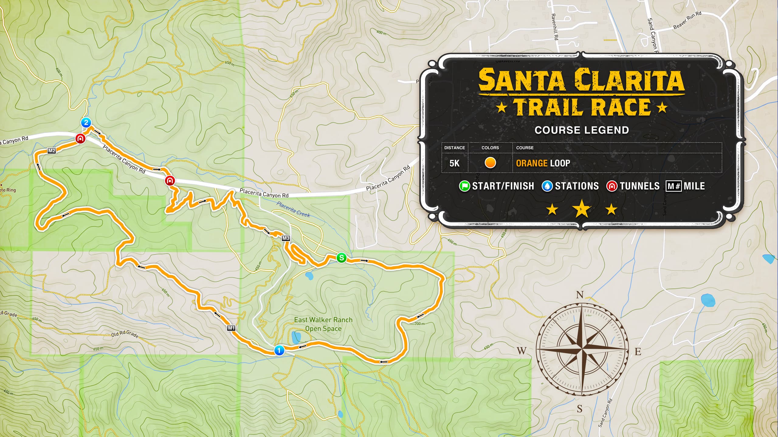

5K runners will complete the ORANGE 5K loop only. From the start, climb a 300-foot elevation gain winding to the top of mountain trails and reaching the East Walker Ranch ridgeline before coming to Station #1. From there runners hit a fun extra-long downhill section that eventually reaches the first tunnel to cross under Placerita Canyon Road and reach the Golden Valley Ranch Open Space.
Coming out of the tunnel runners follow the trail RIGHT (Station #2 is on the left side) to connect to the second tunnel crossing back to the East Walker Ranch side and following the single-track trail back to the finish line to complete the ORANGE loop.
5K runners will visit a total of 2 aid stations through the course. Below is the sequence and approximate mile mark for each station and the gap to the next station on the 5K course.
| STATION | MILE | GAP | NOTES | |
|---|---|---|---|---|
| 1. | Start | 0 | 0.9 | Start ORANGE course |
| 2. | Station #1 | 0.9 | 1.2 | After the ridge line when crossing the road |
| 3. | Station #2 | 2.1 | 1.1 | After the first tunnel on the left side of the fork |
| 4. | Finish | 3.2 | Finish Line |
*Approximate mile mark distances.
The GPS files below can be saved to your computer or phone and uploaded to your app or GPS tracking device. These are XML format files, once you click the button below, save the file then load it into your chosen destination.
*Note - Strava blocks out a section of the course around the start/finish line area.
10K Course
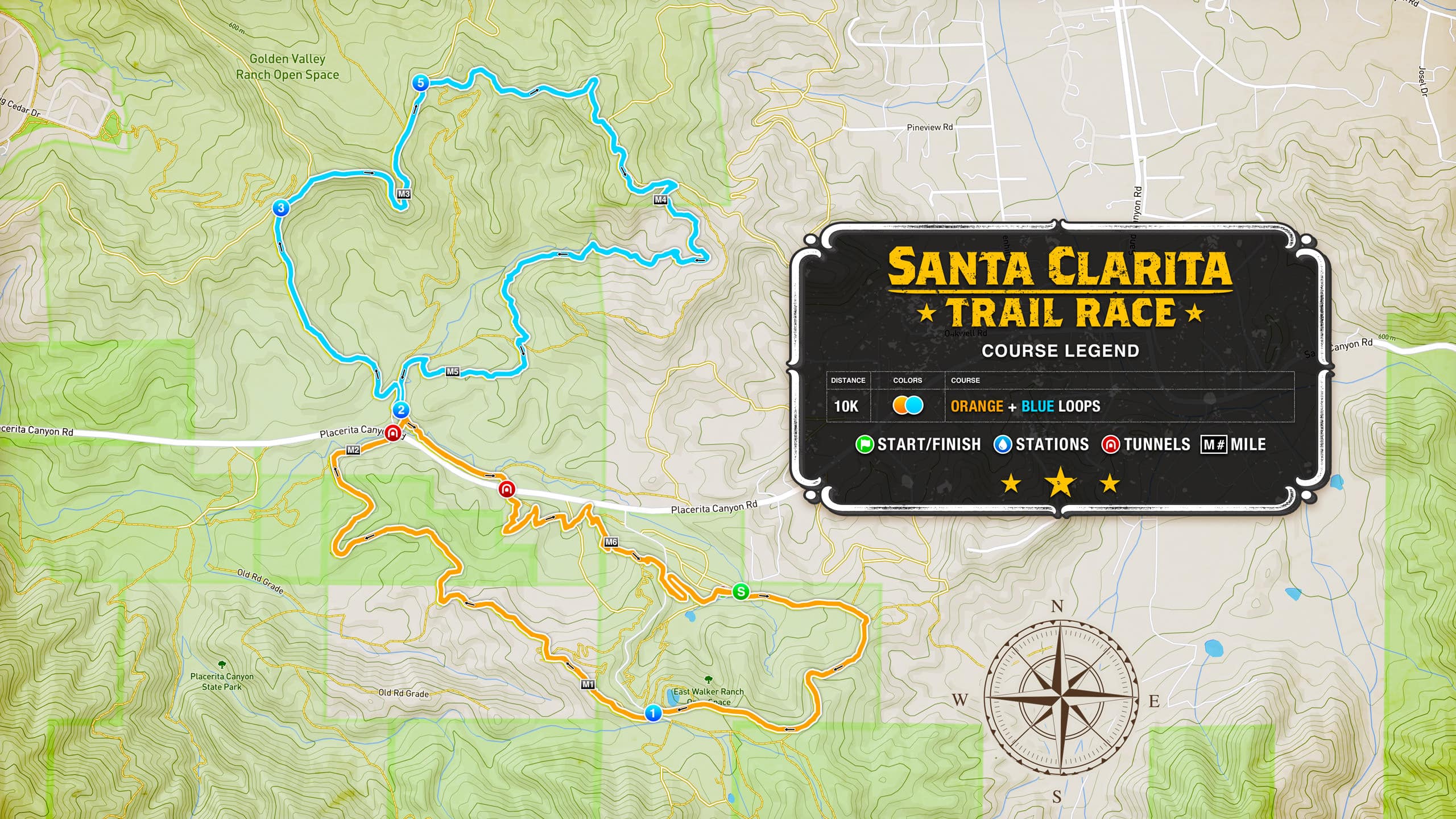

10K runners will complete the ORANGE and BLUE loops. Study the elevation profile above for the color sequence to follow.
From the start following the ORANGE course climb a 300-foot elevation gain winding to the top of mountain trails and reaching the East Walker Ranch ridgeline before coming to Station #1. From there runners hit a fun extra-long downhill section that eventually reaches the first tunnel to cross under Placerita Canyon Road and reach the Golden Valley Ranch Open Space.
Coming out of the tunnel 10K runners follow the trail LEFT to Station #2 to begin the BLUE loop. From #2 start the 350-foot climb to Station #3 and the top of the Golden Valley Ranch. Go RIGHT from #3 and follow the dirt road until arriving at Station #5 (10k runners skip #4).
Going RIGHT from #5 runners start the awesome single-track section until returning to Station #2 to complete the BLUE loop. From there go LEFT to cross the bridge to continue the remainder of the ORANGE loop, connecting to the second tunnel crossing back to the East Walker Ranch side, and following the single-track trail back to the finish line.
10K runners will visit a total of 5 aid stations through the course. Below is the sequence and approximate mile mark for each station and gap to the next station on the 10K course.
| STATION | MILE | GAP | NOTES | |
|---|---|---|---|---|
| 1. | Start | 0 | 0.9 | Start ORANGE course |
| 2. | Station #1 | 0.9 | 1.2 | After the ridge line when crossing the road |
| 3. | Station #2 | 2.1 | 0.6 | After the first tunnel on the left side of the fork, starts the BLUE loop |
| 4. | Station #3 | 2.7 | 0.5 | At the top of the Golden Valley Ranch, the first climb |
| 5. | Station #5 | 3.2 | 1.9 | At the fork that begins the BLUE loop single-track trail |
| 6. | Station #2 | 5.1 | 1.2 | After coming out of the single track to end the BLUE loop and reconnecting to the ORANGE loop |
| 7. | Finish | 6.3 | Finish Line |
*Approximate mile mark distances.
The GPS files below can be saved to your computer or phone and uploaded to your app or GPS tracking device. These are XML format files, once you click the button below, save the file then load it into your chosen destination.
*Note - Strava blocks out a section of the course around the start/finish line area.
Half Marathon Course
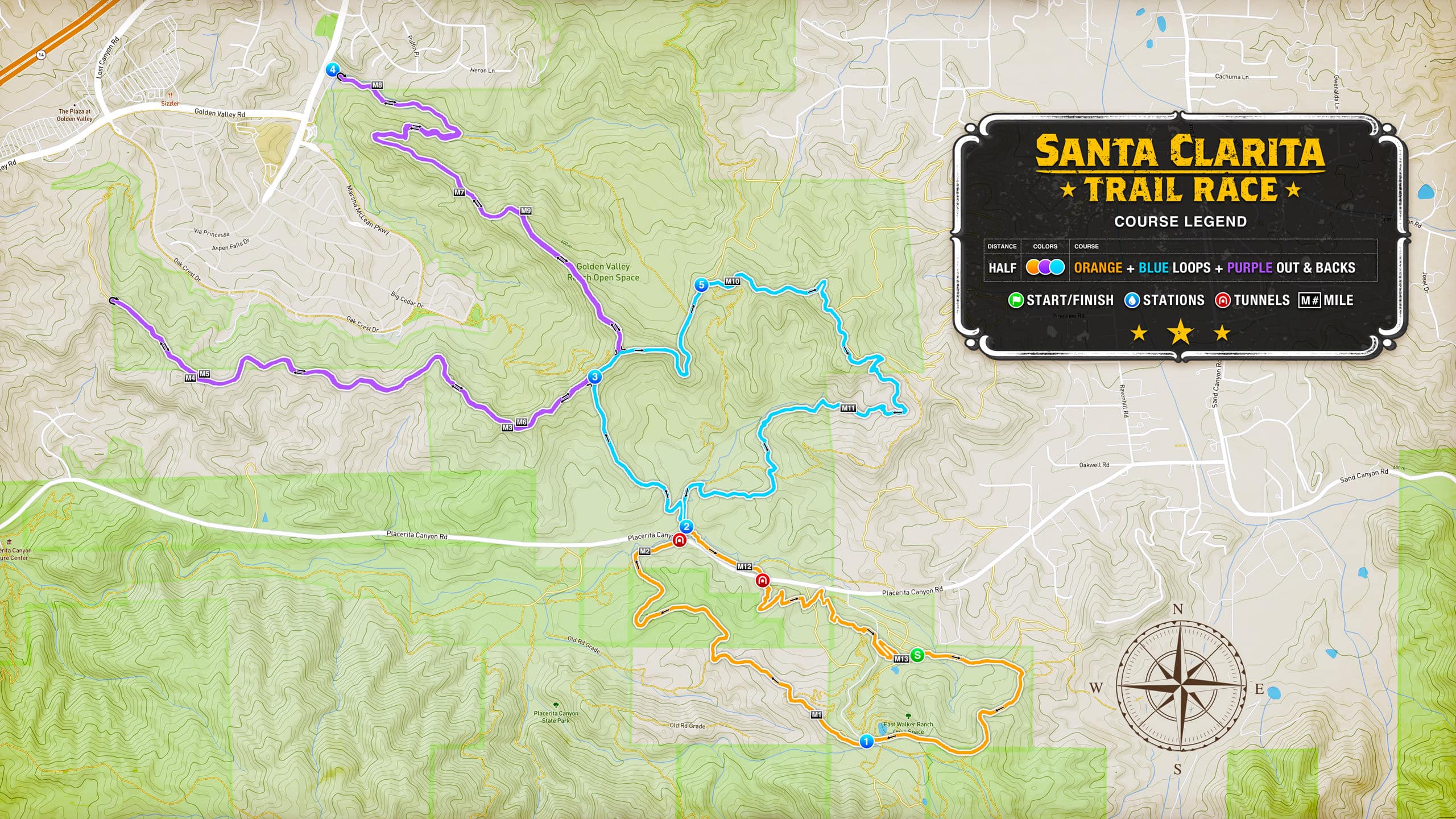

Half Marathon runners will complete the ORANGE and BLUE loops and the two PURPLE out & back sections. Study the elevation profile above for the color sequence to follow.
From the start, following the ORANGE course climb a 300-foot elevation gain winding to the top of mountain trails and reaching the East Walker Ranch ridgeline before coming to Station #1. From there runners hit a fun extra-long downhill section that eventually reaches the first tunnel to cross under Placerita Canyon Road and reach the Golden Valley Ranch Open Space.
Coming out of the tunnel Half Marathon runners follow the trail LEFT to Station #2 to begin the BLUE loop. From #2 start the 350-foot climb to reach Station #3 and the top of the Golden Valley Ranch.
From Station #3, Half Marathon runners go LEFT to begin the first PURPLE out & back section following the route along the ridge to the U-TURN point, then return to Station #3 the second time to complete the first PURPLE out & back section.
From #3 go FORWARD (opposite direction from the first time) back onto the BLUE loop for a short distance to the next road on the LEFT to begin the second PURPLE out & back section. Following the road to the end to reach Station #4, then U-TURN going back to the top to complete the second PURPLE out & back. Now go LEFT onto the BLUE loop towards Station #5.
Following BLUE along the top, runners arrive at Station #5 and start the awesome single-track section until returning to Station #2, completing the BLUE loop. From #2 go LEFT to cross the bridge to continue the remainder of the ORANGE loop, connecting to the second tunnel crossing back to the East Walker Ranch side, and following the single-track trail back to the finish line.
Half Marathon runners will visit a total of 7 aid stations throughout the course. Below is the sequence and approximate mile mark for each station and the gap to the next station on the Half Marathon course.
| STATION | MILE | GAP | NOTES | |
|---|---|---|---|---|
| 1. | Start | 0 | 0.9 | Start ORANGE course |
| 2. | Station #1 | 0.9 | 1.2 | After the ridge line when crossing the road |
| 3. | Station #2 | 2.1 | 0.6 | After the first tunnel on the left side of the fork, start the BLUE loop |
| 4. | Station #3 | 2.7 | 3.6 | At the top of the Golden Valley Ranch first climb, start the first PURPLE out & back |
| 5. | Station #3 | 6.3 | 1.7 | After completing the first PURPLE out & back |
| 6. | Station #4 | 8 | 1.9 | At the end of the second PURPLE out & back |
| 7. | Station #5 | 9.9 | 1.9 | At the fork that starts the BLUE loop single track trail |
| 8. | Station #2 | 11.8 | 1.3 | After coming out of the single track to finish the BLUE loop and reconnecting to the ORANGE loop |
| 9. | Finish | 13.1 | Finish Line |
*Approximate mile mark distances.
The GPS files below can be saved to your computer or phone and uploaded to your app or GPS tracking device. These are XML format files, once you click the button below, save the file then load it into your chosen destination.
*Note - Strava blocks out a section of the course around the start/finish line area.
Disclaimer: Please note that race information here represents what is planned for the Santa Clarita Trail Race. Locations, course variations, and changes may apply depending on conditions, availability, and improvements. We strive to make the best experience for the runners. Thank you for your understanding.
28K Course
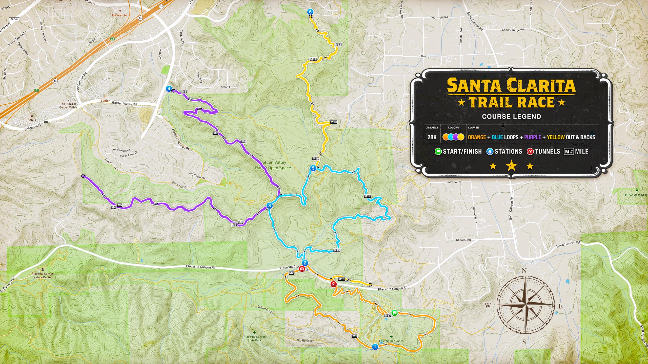

28K runners will complete the ORANGE and BLUE loops and the two PURPLE and YELLOW out & back sections. Study the elevation profile above for the color sequence to follow.
From the start following the ORANGE course, climb a 300-foot elevation gain winding to the top of mountain trails and reaching the East Walker Ranch ridgeline before coming to Station #1. From there runners hit a fun extra-long and fun downhill section that eventually reaches the first tunnel to cross under Placerita Canyon Road and reach the Golden Valley Ranch Open Space.
Coming out of the tunnel 28K runners follow the trail LEFT to Station #2 to begin the BLUE loop. From #2 start the 350-foot climb to reach Station #3 and the top of the Golden Valley Ranch.
From Station #3, 28K runners go LEFT to begin the first PURPLE out & back section following the route along the ridge to the U-TURN point, then return to Station #3 the second time to complete the first PURPLE out & back section.
From #3 go FORWARD (opposite direction from the first time) back onto the BLUE loop for a short distance to the next road on the LEFT to begin the second PURPLE out & back section. Following the road to the end to reach Station #4, then U-TURN going back to the top to complete the second PURPLE out & back. Now go LEFT onto the BLUE loop towards Station #5.
Go FORWARD from Station #5 to begin the YELLOW out & back single-track trail to Station #6. Then U-TURN to follow the trail back to Station #5.
Now going LEFT from #5 runners start the awesome single-track section of the BLUE loop until returning to Station #2, completing the BLUE loop. From #2 go LEFT to cross the bridge to connect and continue on the ORANGE loop.
Shortly after Station #2 and before reaching the second tunnel, 28K runners will take a LEFT for a short YELLOW out & back section before returning to the ORANGE loop to go LEFT to the second tunnel crossing back to the East Walker Ranch side, and following the single-track trail back to the finish line.
28K runners will visit a total of 9 aid stations throughout the course. Below is the sequence and approximate mile mark for each station and the gap to the next station on the 28K course.
| STATION | MILE | GAP | NOTES | |
|---|---|---|---|---|
| 1. | Start | 0 | 0.9 | Start ORANGE course |
| 2. | Station #1 | 0.9 | 1.2 | After the ridge line when crossing the road |
| 3. | Station #2 | 2.1 | 0.6 | After the first tunnel on the left side of the fork, starts the BLUE loop |
| 4. | Station #3 | 2.7 | 3.6 | At the top of the Golden Valley Ranch first climb, start the PURPLE loop |
| 5. | Station #3 | 6.3 | 1.7 | After completing the first PURPLE out & back |
| 6. | Station #4 | 8 | 1.9 | At the U-Turn of the second PURPLE out & back |
| 7. | Station #5 | 9.9 | 1.8 | At the fork that begins the YELLOW out & back |
| 8. | Station #6 | 11.8 | 1.9 | At the U-Turn of the YELLOW out & back |
| 9. | Station #5 | 13.6 | 1.9 | After completing the YELLOW out & back and starting the BLUE loop single-track trail |
| 10. | Station #2 | 15.5 | 1.9 | After coming out of the single track to finish the BLUE loop and reconnecting to the ORANGE loop |
| 11. | Finish | 17.4 | Finish Line |
*Approximate mile mark distances.
The GPS files below can be saved to your computer or phone and uploaded to your app or GPS tracking device. These are XML format files, once you click the button below, save the file then load it into your chosen destination.
*Note - Strava blocks out a section of the course around the start/finish line area.
Disclaimer: Please note that race information here represents what is planned for the Santa Clarita Trail Race. Locations, course variations, and changes may apply depending on conditions, availability, and improvements. We strive to make the best experience for the runners. Thank you for your understanding.
Disclaimer: Please note that race information here represents what is planned for the Santa Clarita Trail Race. Locations, course variations, and changes may apply depending on conditions, availability, and improvements. We strive to make the best experience for the runners. Thank you for your understanding.
Register today to experience the golden trail adventure at the Santa Clarita Trail Race.
The obsession with running is really an obsession with the potential for more and more life.
—George Sheehan


